Four Days in The Ishi
Wilderness, May, 1999
 I'm back from my California adventure, and
I'll try to summarize it below, but I really can't do an adequate job. The
scenery and terrain have to be seen and felt to truly appreciate spending the
time there. But I'll do as best I can.
I'm back from my California adventure, and
I'll try to summarize it below, but I really can't do an adequate job. The
scenery and terrain have to be seen and felt to truly appreciate spending the
time there. But I'll do as best I can.
I left for the airport early Wednesday morning. I mean
early...about 3:30 A.M. on Wednesday, May 5, 1999. I had a 6:30 flight, and
with about an hour and a half drive, and parking the car at a shuttle service
and getting to the airport, that turned out to be just about right. The plane
was on time, and we took off. It wasn't full, so I had no one next to me, and I
tried to rest up a little, knowing it would be a long day. I flew into St.
Louis and had a short layover and change of planes there, and it was off to
Sacramento. The fellow next to me on the plane was interesting and we chatted a
part of the way and exchanged E-mail addresses.....he
is a professor who teaches people who go into disaster areas what to do.
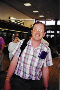
I arrived at Sacramento right on time, and Richard, my author
friend, was there to meet me at the airport. It was a beautiful sunny day, and
we headed to his house to catch up on many things. I met Sharon, and talked to
her for a while, and she soon had to leave for a class she was taking.
We went to the park close to his house, and threw the atlatl a few
times, and I tried to show him how to shoot the bow and arrow the way Ishi did,
which is entirely different from the traditional way that a bow and arrow are
held and shot.
I repacked in order to get ready for the trip to the Ishi
Wilderness the following day. I slept poorly that night, partially because of
the excitement of being in California on the verge of an adventure, and
partially because the couch was just a couple inches too short. So morning came
early, and we prepared to depart.
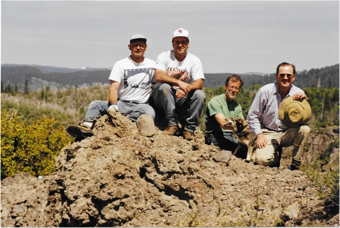
We got our gear ready, and soon Bob Price arrived. I really like
Bob. He is a former park ranger, a big strong fellow, and a really fine fellow.
I had talked him into going to the Natalie MacMaster
concert in California the week preceding, and he was very grateful I had...he
loved her performance, and her.
And off we went toward the north, toward Chico, California, to
pick up the fourth of our party, a fellow named Dave Nopel,
and his dog, Tao. He is a soft spoken fellow in his early
fifties who 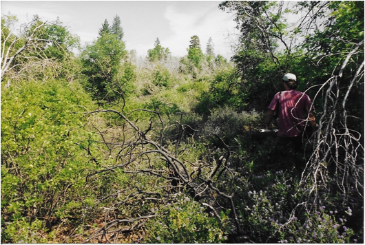 runs a day care with
his wife. He has been to the Ishi Wilderness numerous times since the 1970's,
and knows areas of it quite well. I was, indeed, the rookie of this group.
runs a day care with
his wife. He has been to the Ishi Wilderness numerous times since the 1970's,
and knows areas of it quite well. I was, indeed, the rookie of this group.
We continued north toward less and less population and less and
less traveled roads, until the roads are single lane, rutted and a four-wheel
vehicle is needed. We have a pickup with four-wheel drive and an extended cab.
We finally arrived at our cut off, and we took a road that is made
for off road vehicles only, and went down another half mile or so toward our
final destination. When the road got too bad, and too steep, we stopped, and
Bob parked the truck..
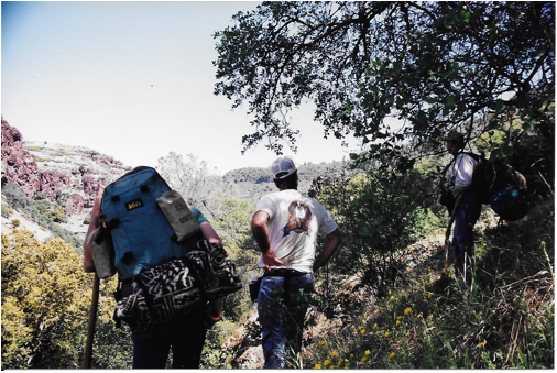
We then headed off to the Ishi Wilderness on foot, with our
backpacks on, and in search of a specific cave that Ishi, the Last Yahi, had
used as a storage cave before his "capture". We headed down a long
walk past an area called Devil's Den, and further and further down we went,
next to this very large valley with large rock formations on either side. The
walking was treacherous because there were so many large loose rocks the size
of your fist or smaller that liked to give way when you stepped on them. With
the backpacks, your weight is distributed differently, so you have to
compensate for that.
Our first wildlife was seen in the form of a small rattlesnake
that slithered for cover under a rock by trail, but kept his or her warning
rattle on so we would know where it was. We left it alone, and continued on.
After a couple of miles, we came to an area that has been called
"Graham's Pinery". Bob, Richard and I had walked some on one end of
this area during my last trip there, and found the brush to be terrible, but
this seemed to be the way to where we needed to go. The only two good things I
can say about Graham's Pinery is that it is flat, and that even though it may
seem endless, there really is an end to it. It was about 2:00 when we had left
the vehicle, and it was approaching 4:00 when we entered the Pinery.
Unfortunately, it had not changed, and the portion we were going
through seemed worse. Thick buck brush, Manzanita, and various other plants,
including the dreaded Poison Oak were everywhere. It was so thick at times that
it was impassable, and we needed to turn around and retreat and find another
way. Trees that had died in the 1990 forest fire had fallen, and in many places
made another barrier we needed to climb over. Remember, this is carrying the
backpacks, making travel slower and more difficult.
About 7:00, we felt we had come far enough along the left ridge to
cut down to the bottom of the canyon the next day, so we searched for a
suitable campsite. There were a few areas where 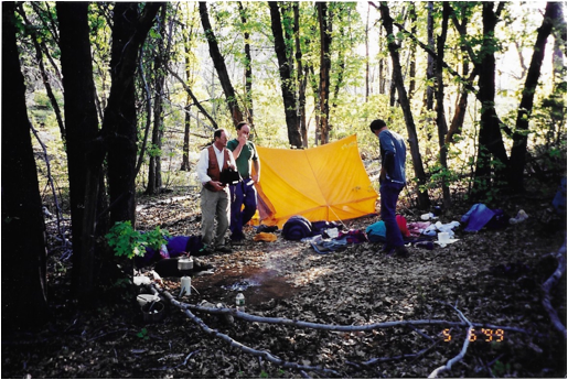 older growth had
survived the fire, so we found an oak clearing, and made camp. Bob and Dave
felt we were running low on water, so they made a "run" to a creek a
ways away for water for drinking and for cooking. The sun was setting fast, so
Richard and I made camp, removing some poison oak from the campsite, and
searching for the most level ground we could find.
older growth had
survived the fire, so we found an oak clearing, and made camp. Bob and Dave
felt we were running low on water, so they made a "run" to a creek a
ways away for water for drinking and for cooking. The sun was setting fast, so
Richard and I made camp, removing some poison oak from the campsite, and
searching for the most level ground we could find.
Bob had brought a small tent, so he and I shared that, while
Richard and Dave slept out under the stars.
They came back with the water just after dark. I had purchased a
pair of small two-way radios to try on the trip, and they worked wonderfully in
situations like this. They would come in useful a number of times when one
person would go out scouting to try to find a way through an impassable site.
Supper consisted of pasta with a tomato base sauce, and a squashed
loaf of bread that tasted quite good. Everyone had worked very hard to get
where we were. Bob went to his backpack and pulled out a bottle of Australian
port wine that we all shared, and we talked about a number of things until it
was time for bed.
I didn't sleep well for a few reasons, the main one being that
ground is hard, the sleeping bag is confining, and we were on a slight slope so
that I kept sliding down toward my feet. In the middle of the night, Bob woke
me up and pointed out that had retreated almost half way out of the tent toward
my feet, due to the slope, so I hitched myself back inside.
The nights are quite chilly, verging on cold, so morning and a
small fire and a cup of coffee was just the right
thing. The plan for the day was to leave Graham's Pinery, and head down toward
Deer Creek, and work the side of Deer Creek in search of the storage cave and a
village site.
We headed down through more brush and poison oak until it opened
up to the majestic buttes and unique rock formations that I had come to
recognize as so much of the Ishi Wilderness. It is beautiful country, but
overwhelming in its breadth and ruggedness. This is not a land of the passive
or the meek, and to think that the Yahi tribe had lived and flourished here for
thousands of  years is almost
incomprehensible to us "modern people".
years is almost
incomprehensible to us "modern people".
The walk down toward Deer Creek was beautiful, but a bit
treacherous, because of the loose rock, the springs that caused footing to be
slippery, and the angle at which we descended at times. It was also long, and
the thought kept going through my mind that each step we descended would soon mean
another step to ascent, since what goes down must eventually have to come up.
Rock pillars the size of cars and city blocks were strewn throughout
the landscape showing signs of violent volcanic activity that fused former
basalt formations with newer lava formations. The caves were the result of
these larger basalt boulders releasing from the lava, essentially leaving a
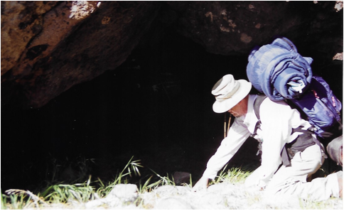
hole, I think. We did find some caves, but no artifacts in them. One could tell
they had been used for many years though because of the black soot that had
built up on the roofs of some of them.
Bob and I headed down toward Wildcat Creek to look at some
interesting rock formations that may have had caves while Richard and Dave
headed toward a larger formation about half a mile away. We kept in touch by
radio. We found some smaller caves, and some beautiful scenery, and Richard and
Dave called that they had found what they believed to be "Legend
Rock", or "The Rock to Which Legend Attaches".
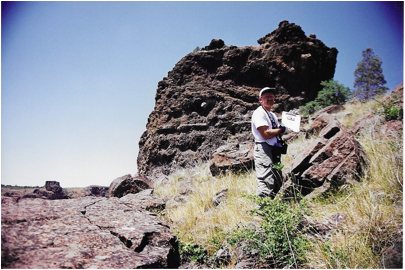
This is a rock formation the size of a small house that sits
overlooking the Deer Creek valley. Richard has a story from one of the people
that returned with Ishi in 1914 to this land, and it was said that the Yahi
used this for a lookout. It also had a hole on the top that
"received" the soul of deer that had been killed, and an observation
hole. Richard and Bob both climbed to the top but it was a bit too steep for my
comfort level, so I waited with Dave. Indeed, they made it to the top.
We documented this find with many photographs, and Richard was
ecstatic that we had found it, since it verified his story.
We were only a third or so of the way down to the Deer Creek, so
down we went, slipping and sliding, and changing course when it got too steep
to continue in one direction. Bob went ahead with his backpack to see if he
could find a way down, and with the radio, was able to keep in touch. He did
find a way down, and on the way, and beautiful cave that seemed undisturbed. On
the base of the cave, he flipped over a rock about a foot in diameter, and
there was a mortar. This mortar was used by the Yahi to grind acorn to a flour, and make acorn mush, a staple of their diet. No one
was even tempted to carry it out for two reasons.
First, we all agreed it should remain where it is because it is a
part of the Yahi culture, and secondly, no one wanted to add thirty pounds to
their backpacks. The cave had a smaller cave next to it that was neat also, and
had been used.
Soon, we reached the waters of Deer Creek. It was rushing by, snow
running off Mount Lassen. Although many people would drink from the stream, we
filtered all of our water just to avoid a terrible parasite called
"giardia". We all went wading and washed off the poison oak and dust
we had accumulated, and filtered water for supper and for use the next day. We
made camp next to the creek, and started a fire for the evening meal of pasta
and Alfredo sauce. Okay, it maybe wasn't totally a low fat meal, but I was
burning enough calories that I didn't worry too much about it!
 We did find that all
of us have an interest in the Civil War, and collecting old books, and Ishi, so
the main topics of discussion centered around those
subjects, as well as using the Internet to access all that information.
We did find that all
of us have an interest in the Civil War, and collecting old books, and Ishi, so
the main topics of discussion centered around those
subjects, as well as using the Internet to access all that information.
And so to bed, for night two in the
Ishi Wilderness. We were in the right place to look for
the storage cave, but we were also in a bit of a predicament in that there was
no clear way back out, unless it was to backtrack where we had been, and this
was next to impossible.
We discussed alternatives to getting out. Dave favored
backtracking to Wildcat Creek, crossing over, and making a long and treacherous
walk to an area called Steamboat, where we would have a long ascent to a cabin,
and then a six mile walk to the vehicle. Another
option would be to attempt to cross the roaring Deer Creek downstream, and take
a long but smooth trail back to the vehicle. About 14 miles
in total. Being a non swimmer, this did not
appeal to me unless I knew I would survive the crossing, and it was a 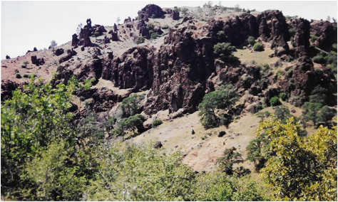 rapid flow.
Bob Price had topographic maps of the area along, and it was his
contention that we could work our way along Deer Creek, search for the cave,
and come to an area where we could climb out of the valley, ascending
approximately 1,000 feet to the other side of Graham's Pinery. This would be
the best way to go IF we could find a way to the top of pinery.
As one viewed the climb, it looked imposing. Okay, it looked impossible.
I could see toward the summit a rock ledge that seemed to continue
along the entire way.
Bob felt that there would be places that we could go that erosion
would have caused openings to reach the top. It was a gamble to go this way,
because if we couldn't get to the top, we would have to fall back to another
plan, and may not be able to get out in time.
But Bob knows his stuff, and can read those maps like they are
3-D, so I felt that was the best way to try. And so we tried to work our way
along the base of Deer Creek. This was another challenge due to the terribly
thick brush, and the angle of the terrain. We wanted to go along, or with the
creek, but the terrain was sloped toward the creek, so we fought this the
entire way.
About 4:30 in the afternoon, and some searching for caves along
our way, we were at the base of the "hill" we needed to climb, and it
was foreboding! It was really steep looking, with no visible way of reaching
the top. Bob went to see if he could find a way that looked passable. The rest
of us descended to the creek below and filled all the containers we had with
water and drank as much as we comfortably could for the long walk ahead. We ate
trail mix and jerky to give us some added energy, and even put some water in a
garbage bag to try to get to the top so we would have water for the coming day.
We also soaked our aching feet!
The original plan was that he would try the ascent by himself,
with his pack, and mark the way and keep in contact by radio, but after scouting
a while and to save time, we decided to all go together.
And so we started up, slowly zig-zagging
to avoid impassable stretches. There were very thick patches of brush that were
too thick to get through, and small springs that softened the ground to make it
very treacherous. We probably shouldn't have crossed some the areas we did, but
somehow we made it safely, and continued the ascent. Some areas were so steep
you could only go about 20 steps and you needed a rest. You had to keep your
weight forward so that if you did slip you did not fall backward, for it was a
long way down.
This was not fun. This was one of those challenges that we meet in
our walk through life...or should I say our climb through life. You can either
give up or go on. Our feet burned, our backs ached, we were reaching
exhaustion, and the unknown lay ahead of us. We went on. I had thoughts of
darkness descending while were ascending, which would have been another
challenge. Ever see those guys who are climbing a mountain, and they have this
little hammock they pitch, and they sleep right on the edge of the mountain? I
didn't want to do that.
We soon were high enough to see the rock summit, and so what we
needed was a fissure or an erosion that was sloped
enough for us to get through to the top. Richard headed to the right, and Bob
to the left. Richard soon returned saying he thought he had found a way, and it
looked like we could get out that way. I talked to Bob on the radio, and he
came back, and off we went for what I was hoping to be the final ascent. Again,
loose rock on a steep slope, and brush made the way difficult, but we did
continue going up. With a few more zigs and few more zags, we 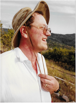 worked our way slowly
to the top, resting often.
worked our way slowly
to the top, resting often.
And then we made it! There had been a trail, probably for deer,
that had cut into the terrain, and allowed the last few hundred feet to the top
of the pinery, and level ground. It was about 7:00,
so we still had some daylight remaining, so after a brief rest, we continued
on. We were on the opposite side of the pinery, so we
would have to head down this side, and then cut over to try to reach our trail
that we had used when we had come in.
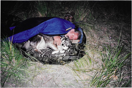
Tao, Dave's dog, was very quiet for the trip, and really stayed
pretty close to him. She had gotten a little limp, but managed to keep up just
fine, and in only a few cases did we need to assist her in coming with us...a
little boost now and then. She did manage to get close enough to a skunk one
day to get sprayed a bit, but it was not overwhelming, just "skunky".
The brush, unfortunately, was as thick as on the other side. We
went for another hour, and about 8:00 found a site to make camp for the night.
We were all really tired, but feeling good about where we were. Bob got the
award for the prettiest blister on his foot, and I photographed it in the
morning for posterity. Supper our last night consisted of ramen noodles and
premixed cups of mashed potatoes, along with some dried fruit and trail mix.
Bob had also kept some peach vodka to drink this last night, and it really
tasted quite good. We got the tent set up, and after some talking and
discussion, we turned in for the night.
The weather again got cool, verging on cold, but the stars shone,
and the next day, the sun shone. Thank goodness! If we had gotten rain where we
were, I doubt if we would have been able to climb out of the valley. And if we
had, I doubt if we could have driven the truck out, because it was a very steep
and slippery place where it was parked. And so the spirit of Ishi continued with
us.
In the morning we packed up for the last time, and had a long
tough walk ahead of us. Richard had come down with a bad case of poison oak, so
his arms, legs, and face were showing the effects of this. It seems very much
like poison ivy, where it affects some people, but not others. I feel so lucky
not to have gotten it because it really is totally unavoidable. It rubs against
your clothing, you grab it for a hand hold, it slaps
against your face. And it is everywhere! Dark valleys, or sunny plains, it will
be there.
About 9:00 we headed east, into the Manzanita, poison oak, buck
brush, and fallen trees, on toward the climb to the vehicle. Eventually, we
came to a more open place where we could hook up with an animal trail, and we
actually made good time. As Bob said later, we made too good a time. We went so
far that we overshot our turnoff, and continued ahead, so that we eventually
had to backtrack a good distance. This, of course, was after the brush
returned, and we needed to bulldoze our way again. I don't think our packs ever
seemed heavier, or our muscles ached more.
We tried to share the burden of the weight so that if one person
got too tired, we would distribute some of his load, and eventually, after many
hours of walking, we reconnected to our trail.
This left only one more challenge to overcome, since our walk to
this point has been downhill on our way in. Yes, indeed, it was now one last
push uphill, on those same slippery and loose rocks, as we ascended toward the
vehicle. We took our time, and about 3:00, we were within striking distance of
the vehicle. Bob had his cellular phone along, so we took time to make a few
calls. I called Joan and my mom, since it was Mother's Day, and I wish they
could have seen from where I was calling!
In about another mile, most of it uphill, we cameto
the vehicle, and we loaded our packs in the back. There was water at the car,
so we drank and ate some remaining sweet stuff, and got ready for the drive
out. I removed my boots and put on some moccasins I had on, and that felt so
good!
And so we headed toward Chico. We decided to find a nice place to
eat, and have one last meal together, before the ride back to Sacramento, but
it was Mother's Day, so most places were quite busy. Richard had remembered
that a local brewery had a very nice eating place called, "The Sierra Nevada Ale
Brewery Company Restaurant", so we went there, cleaned up as best we
could, and shared a pitcher of ale, and a great meal.
We dropped Dave and his dog off in Chico, and headed toward Sacramento,
and a hot shower. I asked Bob if he would buy a topographic map for me, and
draw on the route where we had trekked as a memento, and he said he could put
all three trips on there, in different colors, so that will really be neat to
have.
Richard was happy because he had found Legend Rock, and although
the storage cave had eluded us, he considered the trip a success.
I considered the trip a success too because of what I had
personally accomplished. It was not what I had expected. I did not want a
physical challenge; I wanted to be able to enjoy the majestic scenery and the
mystery of the land, and look for Yahi caves and signs of habitation.
This was definitely the most physically challenging trip I had
ever made, and I had not only survived it, I had kept up with the group the
entire way, and contributed to the success of the trip. If I had any doubts of
my physical conditioning prior to this trip, I do not have them now. As Joan
said when I got home and showed her my legs with multiple abrasions and bruises,
"You should have done this when you younger, but you probably weren't in
as good a shape as you are now!"
We arrived back in Sacramento about 9:30 in the evening, and I
said goodbye to Bob. He is a special kind of guy that I wish I could see more
of and am proud to call my friend.
I took a long hot shower. Richard tried to treat his poison oak as
best he could, but he knew he would need to see a doctor for the right
medication the next day.
Amazingly, I still had trouble sleeping the last night. So much
that we had accomplished, and being so tired, you would think I could have
slept anywhere, but the mind and the body are not always in exact
synchronization, I guess.
The next morning, I had enough time to get my pictures developed,
and exchange pictures with Richard, and then to the airport.
I often think how the internet, and one
note from Richard, led to all of this. It was so gracious of him and Sharon to
take to me in and treat me so wonderfully, and include me on these wonderful
adventures I might not have had.
The flight back was long, but smooth, and all the connections were
on time, so I arrived in Minneapolis at 8:30, got my luggage, got the shuttle
to the car, and drove home. I kept the driver's window down most of the way to
get the cool air on me, and try to stay awake, and I got home about 10:00.
It was good to be home.