Utah, October, 2009
We had a late afternoon flight to Las Vegas, and it was about
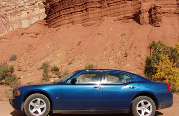
an hour late. The flight was fine, and we landed and got our rental car, a
bright blue Dodge Charger. We headed to the Red Rock Casino for a supper
meal with a girlfriend of Joan's from her high school years, and then headed to
the motel in northern Las Vegas.
 The
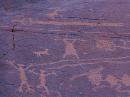
next morning we headed out toward Arches National Park in Utah. We drove
northeast for the majority of the day and just before Arches, stopped at a
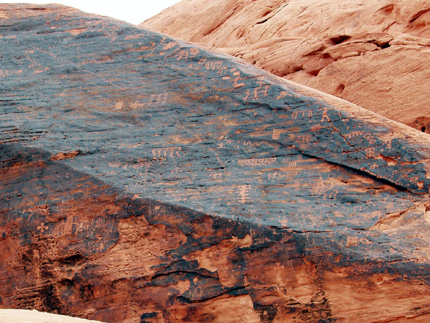
little place out in the wilderness far down a dirt road called "Sego
Canyon". There were several petroglyphs and pictographs, some of them
around 4,000 years old.
The
next morning we headed out toward Arches National Park in Utah. We drove
northeast for the majority of the day and just before Arches, stopped at a
little place out in the wilderness far down a dirt road called "Sego
Canyon". There were several petroglyphs and pictographs, some of them
around 4,000 years old. 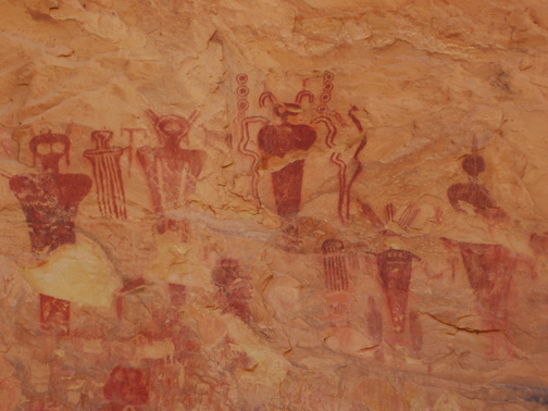 As
you can see from the pictures, these Indians were definitely visited by aliens,
or so it looks like from the pictographs.
As
you can see from the pictures, these Indians were definitely visited by aliens,
or so it looks like from the pictographs.
In case you are interested, petroglyphs are scratched into the
rock, usually scraping off a dark layer so the figures shows up, and pictographs
use dyes to actually stain the light colored rock a different color.
 After
exploring this area, we drove to Moab, where we would be staying for the next
three days. We had a wonderful meal at the Moab Brewery and Restaurant.
After
exploring this area, we drove to Moab, where we would be staying for the next
three days. We had a wonderful meal at the Moab Brewery and Restaurant.
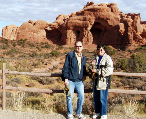
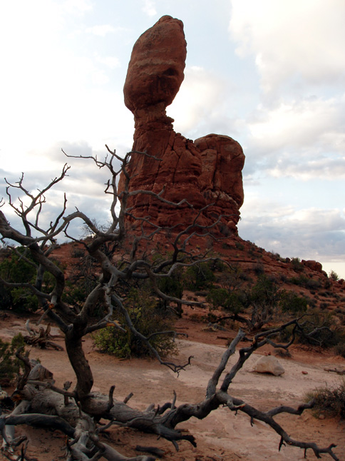
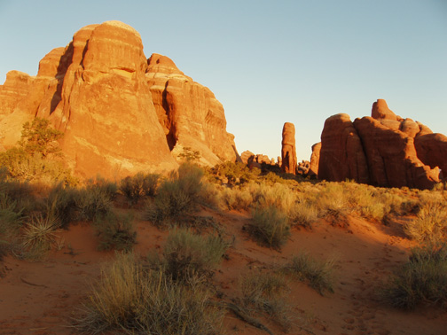
The next morning, early, we headed to Arches National
Park. We were early enough that we were pretty much alone. We walked
to "Balanced Rock", and then to a number of other arches in the park.
The weather was cool and a little cloudy with
rain threatening, but it really never appeared, and soon the clouds
cleared. The country is marvelous. It's such a change from we left
in Minnesota with the red rock landscapes,
the amazing shapes from erosion, and the challenging hills
and valleys
Soon we headed back to the car for more
driving. The roads were good, but very crooked with sharp hairpin curves
in many places. This would be nothing like we drive in a few days,
however!
One of the most famous arches in the park is
called "Delicate Arch", so we felt we should go and see that. That led
to our first adventure.
The literature said that it was a mile and half
hike to the arch. The steepness of the trail wasn't really
mentioned. As we started out, we could see, far in the distance, and
rather large hill, and tiny little figures just barely visible high above
us. It was a bit daunting, but since that was where the arch was, we
decided to head on. It was slow going. Part of trail was fine, but
then another part was on what was called "sliprock", kind of smooth and
a little slippery layer of rock that ran throughout the area. Get a little
loose gravel on it, and it was even slipperier.
After much climbing, numerous rests for a drink
of water, and to catch our breath, we reached the top, only to find that we had
to walk on a relatively narrow trail on the side of the steep hill with a rather
steep dropoff on the other side. Finally, though, around the corner we
came to the very impressive large arch that we had hiked so far 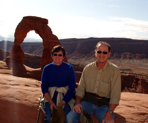
 to
see.
to
see.
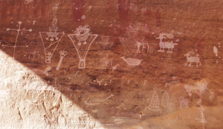
The hike down was easy. We stopped to see some
more petroglyphs, and then headed to a couple more scenic areas. One area
we wanted to see was very crowded with maybe 100 cars, so we decided to wait and
head back there in the early morning.
We headed back to Moab for a late lunch, and ate
at a very nice Italian restaurant. Our legs were a bit achy from the climb, so
it felt good to just sit and relax a while.
Later in the afternoon we went for a drive along
the Colorado River and saw more petroglyphs and pictographs and steep canyon
walls. Some people were climbing the sheer cliffs. This has
absolutely no appeal to me, and even less to Joan.
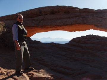
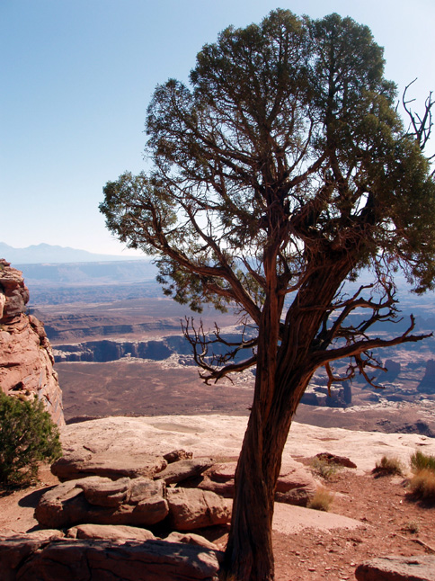
The next morning, bright and early, we headed to
Canyonlands National Park, also close to Moab. This park is a high
plateau, and has steep canyons that have eroded over the millions of
years. We walked to another beautiful arch called "Mesa
Arch". It was huge and you could walk right up to it.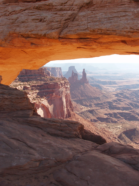
The scenery was, again, spectacular throughout
Canyonlands National Park. We drove further into the park, and gained
quite a bit of altitude. It got cooler, and at literally the end of the road we
walked around at "Grand View Point".
We headed back to Moab for a relaxing lunch and
shopped a bit. Moab is a very nice city, and caters to tourism as its main
industry, so there were many shops to look in. We went to a wonderful rock
shop that had some marvelous displays of fossils and minerals, and bought a
couple little souvenirs of Moab.
Later in the afternoon, we headed off for another
drive on Highway 128 which again was made of steep canyon walls and crooked
roads. After a pretty full day, we headed back to the motel to clean up,
eat a delicious evening meal, and a quiet evening.
 On
Saturday, October 10th, we headed back to Arches National Park in the early
morning to see the sun rise in that area that previously had about a 100
cars. There was no one else there, and we hiked into the
"Devil's Garden" area all alone. There was a chill in the air,
but the sky was clear, and it was incredible to see the first Sun's rays strike
the red rock to make a brilliant orange landscape.
On
Saturday, October 10th, we headed back to Arches National Park in the early
morning to see the sun rise in that area that previously had about a 100
cars. There was no one else there, and we hiked into the
"Devil's Garden" area all alone. There was a chill in the air,
but the sky was clear, and it was incredible to see the first Sun's rays strike
the red rock to make a brilliant orange landscape.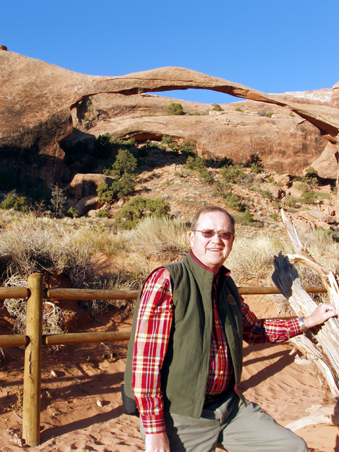
After a walk back on the trail, we came to
another very large arch, this one known as "Landscape Arch" It
was thin and fragile, and they had it fenced off so you could not get close to
it as a safety precaution.
We hiked to another smaller arch, and then headed
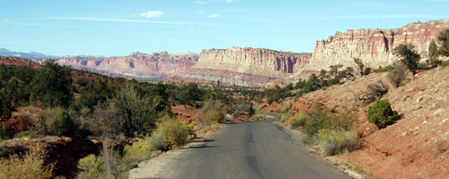
the mile or so back to the car, and on toward Capitol Reef National Park.
This park was again different than the
others. There were white formations, some formations that had sparkly
crystals that looked like diamonds shining in the sun, and some that were the
red rock so common in the entire area.
 The
road went back far into the park, and soon the pavement ended and we had the
option of driving back further on a riverbed that is used as a road when it has
dried up. We drove back a couple miles on the narrow bumpy road, and
parked the car in a small area that had been used by other cars before, and we
walked further down the riverbed perhaps another mile or more. There were
several petroglyphs on the wall along the way, and many pioneers had carved
their names into the blackened rock surface, exposing the whiter rock
underneath. The canyon got narrower and narrower, and the walls steeper
and steeper.
The
road went back far into the park, and soon the pavement ended and we had the
option of driving back further on a riverbed that is used as a road when it has
dried up. We drove back a couple miles on the narrow bumpy road, and
parked the car in a small area that had been used by other cars before, and we
walked further down the riverbed perhaps another mile or more. There were
several petroglyphs on the wall along the way, and many pioneers had carved
their names into the blackened rock surface, exposing the whiter rock
underneath. The canyon got narrower and narrower, and the walls steeper
and steeper.
Soon, we headed back to the car, and drove out
the riverbed and headed to the city of Torrey to get our motel room for the
night. We had read about a great restaurant called "Cafe Diablo"
so we went there for our evening meal, and the meal was fantastic! It was
a gourmet meal with beautiful presentation, and probably one of the best meals
of our trip.
The next morning, Sunday, we headed down Highway
12 driving toward Bryce Canyon National Park. On the way, we stopped at a
state park that had some Anasazi Indian ruins that had been excavated and
rebuilt. Highway 12 ended up being quite an adventure! It was a
scenic drive, but the road was a true mountain road with sharp hairpin curves
and unprotected dropoffs. Part of the road dropped off steeply on both
sides of the road, so we drove on this tiny sliver of land.
 We
arrived at Bryce Canyon, and after a light meal, we headed for another hike from
Sunrise Point to Queen's Garden. This was quite a hike. First, you
walked down a winding trail for almost a mile, then you stayed in the canyons
for about another mile, and then the most challenging, you have to climb back up
that mile you first went down! The shapes and colors and magnitude of
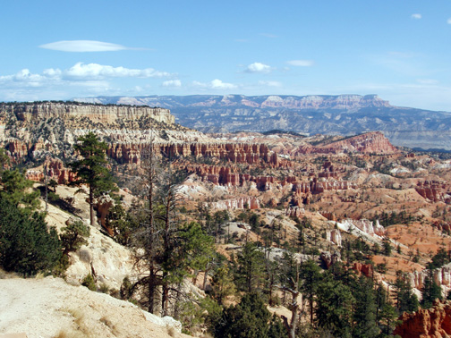
Bryce Canyon National Park is incredible.
We
arrived at Bryce Canyon, and after a light meal, we headed for another hike from
Sunrise Point to Queen's Garden. This was quite a hike. First, you
walked down a winding trail for almost a mile, then you stayed in the canyons
for about another mile, and then the most challenging, you have to climb back up
that mile you first went down! The shapes and colors and magnitude of
Bryce Canyon National Park is incredible. 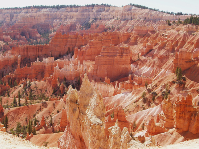 The
colors were the brightest, the pinnacles and peaks absolutely amazing. The
altitude is around 7,000 feet, so there is less oxygen available than we are
used to.
The
colors were the brightest, the pinnacles and peaks absolutely amazing. The
altitude is around 7,000 feet, so there is less oxygen available than we are
used to.
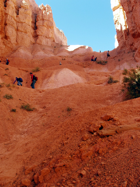 The
climb out of the valley was about 7/10 of a mile up, and it was relatively steep
the majority of the way. At points, the trail zigzagged back and forth on
a narrow trail, switchback after switchback. The picture to the left shows
a picture of people above us on the trail out of the canyon.
The
climb out of the valley was about 7/10 of a mile up, and it was relatively steep
the majority of the way. At points, the trail zigzagged back and forth on
a narrow trail, switchback after switchback. The picture to the left shows
a picture of people above us on the trail out of the canyon.
We were pretty tired by the time we got to the
top of the trail, but we could see why some of the literature called this
"The world's best three mile hike". It was beautiful and
memorable.
We drove through other parts of the park,
including an area that had had a recent forest fire, and took in some more views
before heading for our evening meal and the motel.
Early in the morning we went back into the edge
of Bryce Canyon for a sunrise view of Fairyland Point, and then on toward Zion
National Park.
We took Highway 9, which was quite an experience
in itself. We drove through a tunnel that was 1.1 miles long! It had
been built in the 1920's for vehicles at that time, so it was pretty narrow by
today's standards. 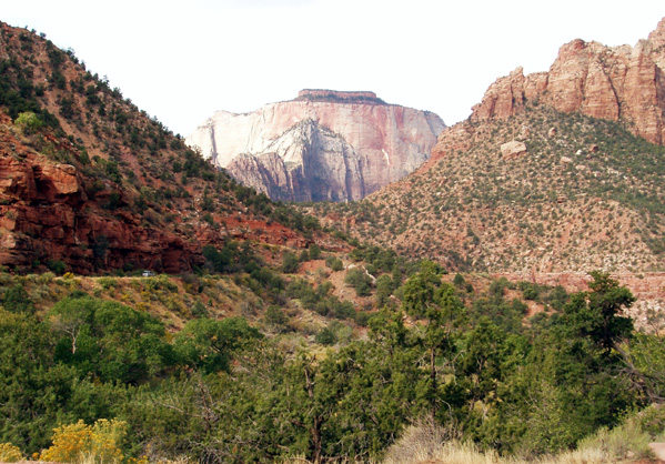 Large trucks and trailers have to be escorted through while traffic is stopped
from the other direction. There were a few "windows" put in
throughout the tunnel, probably for an air supply.
Large trucks and trailers have to be escorted through while traffic is stopped
from the other direction. There were a few "windows" put in
throughout the tunnel, probably for an air supply.
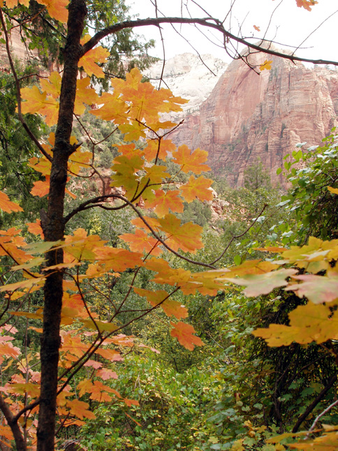
Zion reminded me of Yosemite in some ways with the mighty
hills that looked like granite. Zion National Park controls the traffic in the
park by the use of free shuttles. You need to park your car at the
entrance, and take the shuttles to the various locations. While there are
lots of shuttles, with very little waiting, this does put you in with the
crowds, so we seldom had places to ourselves as we often do. 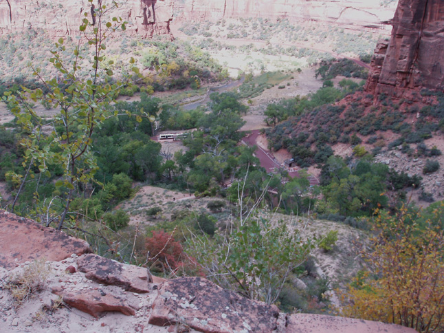 We
took one more steep hike while in the park.
We
took one more steep hike while in the park.
We actually took a wrong trail, and ended up walking longer
and higher than we had planned, but the view was terrific.
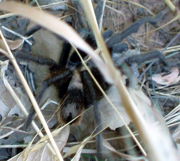 We
went on a couple more hikes in the park, and on one of them, we ran into a
creature we had never seen in the wild before....a tarantula! It was on
the side of the trail, and we wouldn't have noticed it but there were other
people who had spotted it and they were taking its picture. It was large, maybe
four inches across!
We
went on a couple more hikes in the park, and on one of them, we ran into a
creature we had never seen in the wild before....a tarantula! It was on
the side of the trail, and we wouldn't have noticed it but there were other
people who had spotted it and they were taking its picture. It was large, maybe
four inches across!
Later in the afternoon, we headed back for our evening
meal and the motel. We had a delicious handmade pizza at a very nice
restaurant close to the motel. The setting was very nice, tucked right
into the scenic hills.
The next morning, Tuesday, we headed toward Las Vegas and our
late afternoon flight. On the way, we stopped at a neat state park called
"Valley of Fire". It was a very nice and interesting
break to the drive, and we spent a couple hours there looking around.
 We
went on a long hike down a sandy creek bed that had numerous petroglyphs on the
canyon walls.
We
went on a long hike down a sandy creek bed that had numerous petroglyphs on the
canyon walls.
It was a pretty hike, though the shifting sand sometimes made
walking difficult. It was warm with the sun shining down on the desert
landscape.
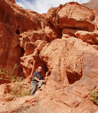
One of our last hikes was to a number of
petroglyphs that included drawings of a man throwing an atlatl (pronounced
at-LAT-ul), which is a primitive throwing stick that preceded the invention of
the bow and arrow.
 Since
I have an atlatl myself, and throw it periodically, I was anxious to see
that.
Since
I have an atlatl myself, and throw it periodically, I was anxious to see
that.
 I
climbed a steep path to get a glimpse of one more arch before we headed out
toward Las Vegas.
I
climbed a steep path to get a glimpse of one more arch before we headed out
toward Las Vegas.
The Dodge Charger had been a good car. The
only criticism I have of it is that it is a bit low, and we "bottomed
out" a couple times on a couple of rough areas on dirt roads.
We returned the car to the rental agency, took
the shuttle bus to the airport, took the tram to the right terminal and waited
for our flight. There are lots of slot machines in the Las Vegas airport,
so I did a little gambling, and won $100.00. Being my wild and crazy self,
I immediately cashed it in.
Our flight was basically on time, and we got back
home about 1:00 A.M.
A fun trip, with lots of sights, a few
adventures, and great memories.